- Your Government
-
Our Community
-
- About St. Helens History of St. HelensState of the CityCourthouse Dock Camera
- Local Events City Calendar Citizens Day in the ParkRecreation Activities Discover Columbia County Sand Island CampingKeep It Local CC
- Community Resources City Newsletter City Social Media Emergency Services New Resident InformationProtecting Our Environment
-
-
Business & Development
-
- Local Business Directory Get a Business License City Bids & RFPs Broadband Study
- Business in St. Helens St. Helens Advantages Directions & Transportation Incentives & Financing Resources for Businesses Business Guide Columbia Economic Team Chamber of Commerce
- Current City Projects Waterfront Redevelopment Public Safety Facility Strategic Work Plan
-
-
How Do I?
-
- Apply for a Job Apply for a Committee Find A Park Find COVID Info Find Forms Follow St. Helens - Facebook Follow St. Helens - Twitter Follow St. Helens - YouTube
- Get a Police Report Get a Business License Get a Library Card Get a Building Permit Newsletter Signup Past Public Meetings Pay My Water Bill
- Public Records Request Report a Nuisance Register for Rec Activity Reserve a Park Sign Up for the 911 Alerts Universal Fee Schedule
-
St. Helens Hosts Joint Meeting to Give Riverfront Project Update
FOR IMMEDIATE RELEASE
March 3, 2022
St. Helens, Ore. – The St. Helens City Council and Planning Commission are holding a joint meeting on Wednesday, March 16, 2022, at 5:30 p.m. to review progress on the St. Helens Riverfront Project. The meeting will be an opportunity for the City’s consultants to provide an update on the design efforts specific to the Streets and Utilities Extension Project.
Otak, Inc. is the City’s project engineer and Mayer/Reed, Inc. is the City’s landscape architect for the project. The consultants will present the newest project design which is currently 90% complete. Groundbreaking for the Streets and Utilities Extension Project is anticipated to begin in 2022. This project is only focused on public infrastructure and does not include any private development component.
The community is invited to attend the joint meeting to learn about the design either in person or virtually. The meeting is being hosted in the St. Helens Council Chambers. Space is limited, but the presentation will be live streamed on the City’s YouTube page and on Zoom. A recording of the presentation will also be available to watch online the following day. This meeting is intended for the City Council and Planning Commission to review the latest design updates from the City’s consultants and is not being held as a community open house. Because of this, there will be limited opportunity for public comment during the meeting.
The City of St. Helens launched the Streets and Utilities Extension Project in March 2021. The project is focused on creating design documents, securing permits, and constructing street and utility extensions for South 1st Street and Strand Street through the St. Helens waterfront property. Street extension design has been focused on creating safe pedestrian connections, inviting intersection treatments, and providing ample on-street parking. Pedestrian amenities such as landscaped seating, interpretive and wayfinding signage, more visible crosswalks, and consistent light fixtures throughout the existing area and onto the property are designed to create a cohesive Riverfront District.
The March 16 presentation will include a description of the design along South 1st Street, beginning at Cowlitz Street and extending south through the waterfront property to Plymouth Street. The pedestrian network design for the bluff trail connecting Nob Hill Nature Park, the Tualatin Street staircase, and ultimately the future Riverwalk Project pathway at the south end of the site will also be reviewed. The bluff trail will be located immediately west of the new South 1st Street roadway. Its connection with the Riverwalk Project pathway will create a complete off-street pedestrian loop through the property, similar to the interim trail route on the site today. To see the current Riverwalk Project plans, visit the project’s website at www.sthelensoregon.gov/waterfront/page/riverwalk-project.
The presentation will review how pedestrian safety on Strand Street will be improved in front of City Hall. It will also show how Cowlitz Street will be extended onto the waterfront property with a traffic circle just south of Columbia View Park. The extension of Strand Street onto the property and its connection to South 1st Street will also be reviewed.
The meeting presentation will be posted on the City’s website on March 15, 2022. The meeting is being held in the Council Chambers at City Hall, 265 Strand Street, Plaza Entrance, St. Helens, OR 97051. The facility is handicap accessible. If you need special accommodations, please contact City Hall at 503-397-6272 at least 48 hours before the meeting.
Project Background
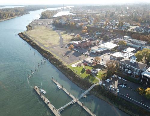
The City of St. Helens is currently working on two riverfront projects to bring major infrastructure and public amenity improvements to the St. Helens waterfront. Both projects are focused on infrastructure development on the former Boise veneer property. The property is a vacant 22-acre, half-mile long piece of property. It is bordered by the Columbia River to the east, Columbia View Park and the historic St. Helens Riverfront District to the north, Nob Hill Nature Park to the southwest, and Plymouth Street at its south end. The site is commonly referred to as the St. Helens waterfront property.
While the purpose of the upcoming meeting focuses on the Streets and Utilities Extension Project, the City also launched the Riverwalk Project in March 2021 to design public access on the St. Helens waterfront property and a new stage for the Columbia View Park amphitheater. The riverwalk will extend along the banks of the Columbia River from Columbia View Park to Plymouth Street and Nob Hill Nature Park. The new linear park design will incorporate a combination of pathways, boardwalks, and overlooks.
Both projects are part of the City’s ongoing efforts to open a large expanse of riverfront property that was formerly private industrial land fenced off from community access. With the City’s purchase of the property in 2015, major planning and design work has taken place to reclaim the waterfront to serve the St. Helens community in new ways. This redevelopment process aims to pay homage to both the past and future of the city by creating new amenities to attract new business and residents to St. Helens and provide guaranteed public access to a larger stretch of the Columbia River.
###
For further information regarding this meeting, please contact Communications Officer Crystal King at cking@sthelensoregon.gov.